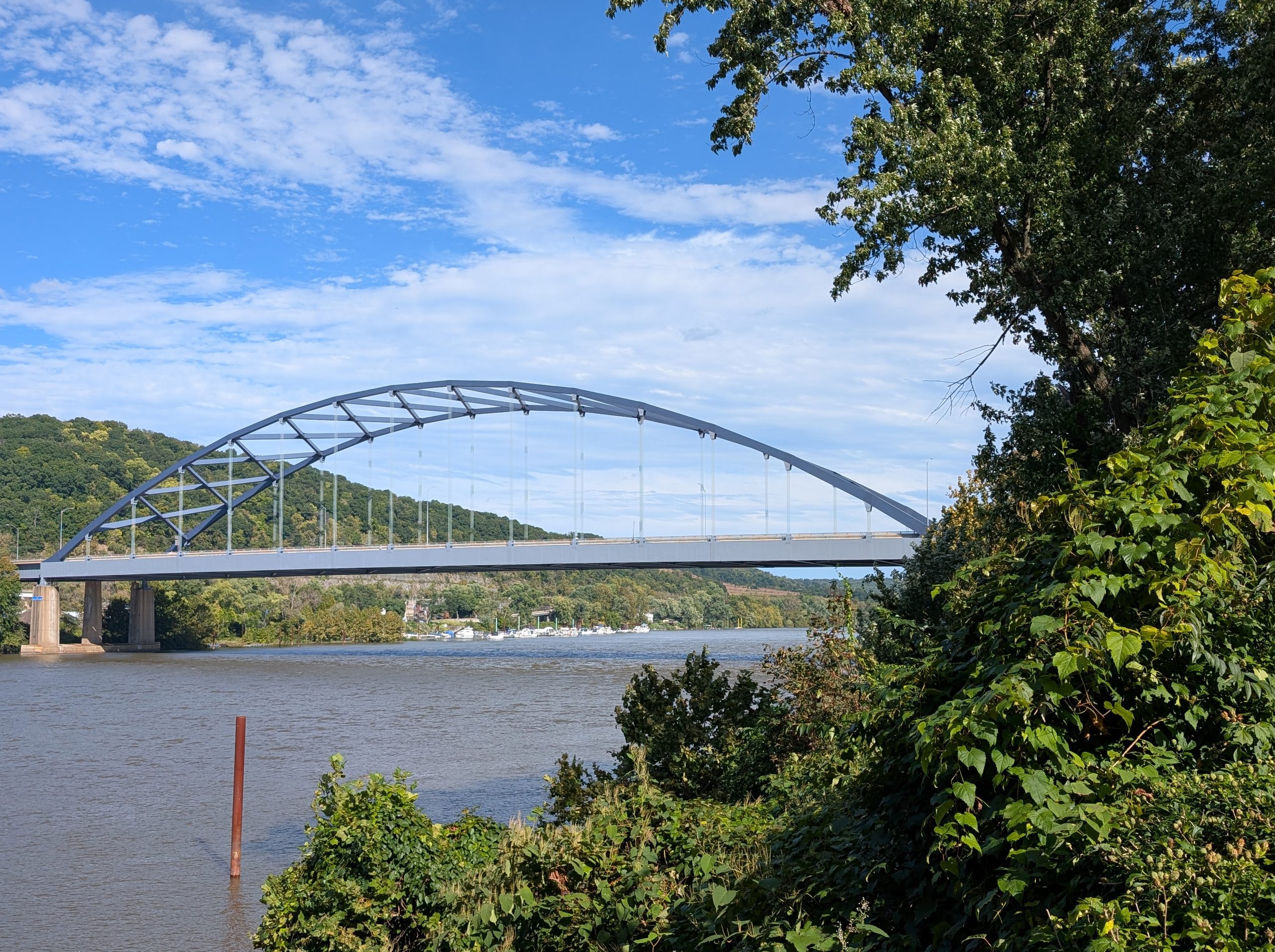
A long blue-gray bow over the Ohio, and the story of the steel inside it
Coming down the Ohio from Pittsburgh, past the shipyard ghosts and tank farms of Neville Island, the river bends and a single arch comes into view. It sits on the water like a drawn bow, with a row of thin hangers dropping from the curve to the roadway like strings on a harp. Fifty-some thousand vehicles a day ride across it on Interstate 79, and from the deck you barely see it at all. From the riverbank, with the hills of Glenfield behind it and a marina tucked under its south end, it looks like someone drew one confident line across the valley and left it there.
That line is the Neville Island Bridge, and it earns a closer look.
The last link
Interstate 79 runs 180 miles across western Pennsylvania, from the West Virginia line to Erie. The crossing at Neville Island was the final piece to fall into place. Construction ran from 1971 to 1976, and PennDOT’s own engineers designed it. When the ribbon was cut in late 1976, the bridge closed the gap in the whole route.
The name most people use undersells it. The bridge is a complex: ramps, a roadway that crosses Neville Island about 40 feet above the ground, and three river crossings. The back channel, between the island and the south shore at Groveton, gets a pair of near-twin steel deck girder spans of about 300 feet each, one carrying the six lanes of I-79 and the other carrying the single-lane exit ramp to the island. The ramps themselves are box girders. The showpiece, and the subject here, is the main channel span: a steel through tied arch carrying six lanes of traffic, with the deck sitting 68 feet above the river.
Its official name is the Pittsburgh Naval & Shipbuilders Memorial Bridge 1941–1945, and the name is earned by the island underneath it. During the Second World War, the Dravo Corporation turned Neville Island into an inland shipyard and built 146 LSTs there, the flat-bottomed tank landing ships that carried armor onto beaches. The yard was laid out to work on twelve LSTs at once. Ships launched here sailed down the Ohio and Mississippi to the Gulf before heading to war. On Memorial Day 1944, more than 25,000 people turned out to watch the launch of LST-750, a ship Allegheny County residents paid for by buying $5 million in extra war bonds. A bridge named for those shipbuilders now stands over the water where their hulls slid in.
How a tied arch works
An arch carries load by pushing. Weight on the curve travels down along the rib and into the feet, and those feet want to spread outward the way your hands slide apart when you press down on a tent pole bent between them. On a stone bridge over a gorge, the canyon walls take that outward shove. In the middle of a river, with soft ground and navigation channels, you don’t get canyon walls.
A tied arch solves this by bringing its own rock along. The roadway deck includes a heavy horizontal member, the tie, that connects the two ends of the arch and holds them together the way a bowstring holds the ends of a bow. The arch pushes outward; the tie pulls back inward; the forces cancel inside the structure. What reaches the piers is mostly straight-down weight, which makes the bridge easy on its foundations. That’s why the name “bowstring arch” fits so well here: the visual and the mechanics are the same thing.
The hangers are the third part of the system. The deck hangs from the arch on those vertical members, so the arch rib lifts the roadway and the tie keeps the arch from flattening. Looking at the bridge from the shore, you’re seeing a closed loop of forces: compression in the curve, tension in the hangers, tension in the tie.
The main span measures 725 feet, second-longest single span in Allegheny County behind the West End Bridge at 755. It edges the Sewickley Bridge, about two and a half miles downstream, by one foot. It was built alongside the Birmingham Bridge over the Monongahela, which shares its look on a channel span about 100 feet shorter, so Pittsburgh has a matched pair of these bows on two of its rivers.
The line it rides
Part of the bridge’s good looks comes from where it sits. The highway enters through the Kilbuck Run valley in Glenfield, a natural notch in the hills on the north shore, and runs in a straight line across both river channels and the island for more than a mile. In western Pennsylvania, where roads usually bend around one ridge after another, a mile of dead-straight highway is close to a geological rarity. South of the island the road gives the hills their due again, with a string of 45 mph curves and the opposing lanes at different elevations.
There’s a small piece of whimsy built in, too. Bicycles are allowed on the shoulder of the main channel crossing between the Glenfield and Neville Island exits, one of the few stretches of Interstate in the region where a cyclist can legally ride.
The crack
Five months after the ribbon-cutting, on January 28, 1977, towboat captain Steve Muick was breaking ice in the back channel at the helm of a crane-equipped barge called the Ranger. He was checking whether his crane boom would clear the underside of the bridge when he saw the girder above him was split. The crack ran ten feet, top to bottom, through a girder of three-inch-thick steel, and the fissure in the bottom flange gaped three inches wide. It was the outermost girder on the northbound side, and it carried weight from six lanes. Muick called the State Police, and the back channel span was shut down immediately.
It stayed closed three months. Crews used hydraulic jacks to force the crack closed, then bolted heavy plates across it as a splice. The bridge reopened March 31, 1977. The timing was rough on the region: the nearby Sewickley Bridge closed around the same time, as hard cold worsened damage already known on that older span.
The cause traced to the welding. The crack sat right beside an electroslag weld, a fast process for joining thick plate that generates intense heat. The other electroslag welds on the bridge were reinspected and nine were reinforced. Bridges built in the same period, the Birmingham Bridge among them, were checked and repaired. The Federal Highway Administration then barred electroslag welding on bridge tension members. One towboat captain’s sharp eye on an icy morning ended up changing how steel bridges get built across the country.
The arch itself had its own lesson to teach later. In 1983, inspectors found cracks in the welds connecting the diaphragms to the web of the tie girder. Lehigh University’s Fritz Engineering Laboratory, working with PennDOT, traced them to lack of fusion in the welds, followed by fatigue: as trucks rolled across, the floor beams twisted the tie girder’s web in a small gap at the box corners, flexing the steel back and forth like a paperclip bent until it tires. The fix was a positive bolted splice tying the floor beam flange to the tie girder flange. That study and the 1977 crack became case material in the engineering literature on fracture in welded bridges. More hairline cracks were found in the girders in 1999 and addressed in turn.
Kept up
A bridge this busy gets regular attention. PennDOT finished a $20.8 million improvement in 2010. A larger rehabilitation ran from 2021 into 2024, with structural steel repairs, new bearings and deck joints, deck and concrete work, and a full repainting of the structure, arch ribs included. The final price came in around $48 million, and the job supported about 80 jobs over three years. The coat of blue-gray the arch wears now dates from that work, and against a September sky it reads like the river and the clouds agreed on a color.
Flowers
A lot of 1970s highway steel was built to be unseen. The Neville Island Bridge got built to be useful and came out handsome anyway, and the reason is restraint. The arch rib is slender for a span this long, a single unbroken curve with no fussy trusswork along its length. The lateral bracing between the twin ribs stays up in the crown, a light lattice where it does its job, leaving the ends of the arch open and clean as they come down to meet the deck. The tie girder runs flat and level beneath, a straight edge under a curve, the way a ruler sits under a compass arc on a draftsman’s table. The hangers are thin enough to disappear at a distance, so the deck seems to float.
There’s an honesty to it that’s easy to love. Every visible piece does something you can name: the curve pushes, the hangers lift, the tie holds. Stand on the Coraopolis shore with the hills behind it and the boats bobbing under the south pier, and the bridge looks less like an interchange than like a single gesture — one long bow drawn across the Ohio, strung tight, and holding.
A simple beauty. It carries its history in its welds and its name, and it still makes the river look good.
Sources
- Bridges and Tunnels of Allegheny County and Pittsburgh (pghbridges.com): I-79 Neville Island Bridge (main channel); I-79 Neville Island Back Channel Bridge; “The Award-Winning Bridge That Failed,” Pittsburgh Press Roto, June 5, 1977
- WPXI, “On This Day: January 28, 1977, Massive crack threatens I-79 Glenfield Bridge with collapse”
- Fisher, Pense, Menzemer, Kauffman, “Final Report on I-79 Tied Arch Cracking — Neville Island Bridge,” Lehigh University Fritz Engineering Laboratory / PennDOT, 1984 (TRID record)
- Fisher, Pense, Hausammann, “Analysis of Cracking of I-79 Bridge at Neville Island,” ASCE, 1985
- Wikipedia, “Neville Island Bridge”
- Office of the Governor of Pennsylvania, 2024 press release on completion of the I-79 Neville Island Bridge Rehabilitation Project
- Construction Equipment Guide, “Trumbull Tackles ‘a Little Bit of Everything’ on Ohio River Crossing”
- The Lean Submariner, “Pittsburgh Pennsylvania – Serving the Navy in World War 2”
- KDKA / CBS Pittsburgh coverage of LST 325’s Ohio River visit
- American Legion memorial listing, Neville Township Memorial