Downshifting through 2 billion years.
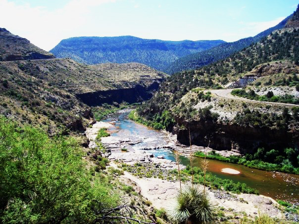
There’s a place on US 60 in eastern Arizona where the road stops behaving like a road. The pavement runs across flat scrub and juniper, gives you no warning worth the name, and then the ground opens. Two thousand feet of it. The highway responds by folding itself into switchbacks down the north wall, crossing the water, and climbing the south wall the same way it came down. Riders call it the Salt River Canyon. Some call it the Mini Grand Canyon, which undersells it, because in one respect this canyon shows you more than the Grand Canyon does.
I rode it in 2009. It has stayed in my top five ever since, and I live in the Alleghenies, where good road is the local crop.
What the road is cutting through
Start at the bottom and work up, because that’s the order the earth laid it down.
The oldest rock in the canyon is Pinal Schist, somewhere around 1.7 billion years old. It began as mud and sand on an ocean floor, got buried, cooked, squeezed, and turned into a foliated metamorphic rock that reads like a book left out in the rain. That schist is basement. Everything above it is a later tenant.
On top of the schist sits the Apache Group — Pioneer Formation, Dripping Spring Quartzite, Mescal Limestone — deposited roughly 1.2 to 1.1 billion years ago, in the long Precambrian stretch when the only life on the planet was microbial. The Mescal Limestone holds stromatolites, the layered mounds built by cyanobacteria mats. Those are among the oldest fossils you can look at from a motorcycle.
Then something pushed through. Around 1.1 billion years ago, molten diabase intruded the Apache Group as sills, shouldering between layers and baking their contacts. You can pick the diabase out by its dark, blocky, rusty-weathering habit against the paler quartzite.
Above that comes the Great Unconformity — a missing stretch of several hundred million years where no record was kept, or where the record was stripped off before the next layer arrived. Then the Paleozoic: Devonian and Mississippian marine limestones from warm shallow seas, Pennsylvanian units above them. And capping the rims in places, Tertiary volcanics, basalt flows a few tens of millions of years old lying across rock nearly two billion years their senior.
So the wall you’re looking at across the gorge is a stacked chronology with most of Earth’s history in it, and the top of that stack is thin frosting.
Why there’s a canyon here at all
Rock that old doesn’t guarantee a canyon. The cut is young — a few million years, likely less. Two things made it.
First, the Salt River sits in Arizona’s Transition Zone, the structurally broken country between the Colorado Plateau to the north and the Basin and Range to the south. Faulting here gave the river lines of weakness to exploit, and the river took them.
Second, base level dropped. As Basin and Range extension pulled the crust apart to the south and the regional drainage integrated toward the Gila and the Colorado, the Salt River found itself with a great deal more elevation to give up and a shorter distance to do it in. A river with surplus gradient behaves like a saw. It cut down faster than the walls could slump back, which is why the canyon has that hard-shouldered, freshly opened look instead of the softened V of an old drainage.
The river also earns its name. Saline springs feed it, most famously at the Salt Banks downstream, where mineral-charged water has built terraces of travertine streaked in colors that don’t belong on a desert riverbank. The site is sacred to the Apache and sits within the Fort Apache Reservation. The canyon is a boundary as well as a landform: San Carlos Apache to the south, White Mountain Apache to the north, the river between them.
What Appalachia does differently
I ride at home in country that is older as landscape and younger as rock, which is a strange thing to say until you sit with it.
The ridges around Johnstown are folded Paleozoic sediments — Devonian through Pennsylvanian, the same broad ages as the middle of the Salt River section, wrinkled up during the Alleghanian orogeny about 300 million years ago when Africa came calling. Since then: nothing but erosion. Three hundred million years of weather working a mountain range down to its roots. The Conemaugh cuts its gorge through Laurel Hill because the drainage was there before the ridge finished rising, and it kept sawing.
The result is a different kind of road. Appalachian riding is a matter of endless second- and third-gear rhythm through a hardwood tunnel, sight lines closed by leaf, elevation change delivered in installments, and a surface that spends every winter being taken apart by frost. You ride texture. You ride what water and freeze-thaw have done to a mountain over an unimaginable stretch of time with no new uplift to replace what was lost.
The Salt River Canyon is the opposite instrument. Sight lines are enormous. You see the entire descent before you commit to it, the far wall stacked and labeled, the river a green thread at the bottom. Temperature drops as you go down and comes back as you climb out. Nothing is hidden by canopy. There’s no leaf litter, no shale slide, no logging truck in the blind right-hander. The road hands you the whole problem at once and lets you solve it in the open.
It’s the exposure that makes it. Most great motorcycle roads make you take the landscape on faith one corner at a time. This one shows you where you are, how far down you’re going, and roughly two billion years of why.
Seventeen years and the memory still holds its shape. That’s the review.