A Bright Meadow Group sketch of a federal high-speed rail network, built outward from the Texas junction
Lone Star Junction put a pin in Texas and called it the knot in the continent’s bow tie. This piece draws the strings. Tie the knot in Texas, run the lines north to Chicago and out to the coasts, and the country gains something it has lacked since the passenger train faded: a way for people and ideas to move between cities as easily as a phone call moves between them.
The goal is simple. Connect the cities and the universities. Make brains mobile. A researcher in Austin should be able to sit in on a seminar in Lawrence and be home for dinner. A student in Norman should be able to spend a Saturday in a Minneapolis lab. Put the minds within reach of each other and industry will find a way to use what they build.
OBSERVE
The country has done this before. In 1956 Congress passed the Interstate Highway Act and drew a national road map in one stroke. Federal money paid the bulk of the bill, federal standards set the design, and the states did the building. Forty-some thousand miles of interstate followed. That model is sitting on the shelf, ready to be pulled down and pointed at rail.
The rights-of-way already exist. The railroads laid out their corridors more than a century ago, and many of them still run straight and flat across the Plains and the Gulf Coast. The interstates added a second set of corridors with wide center medians. Between the two, a national network can follow lines already surveyed, graded and owned.
The rail lines have been in public hands before. When the Northeastern railroads went bankrupt in the 1970s, Congress folded them into Conrail. Amtrak already holds a federal power to ask the Surface Transportation Board for rail-carrier property it needs for intercity passenger service, provided freight service isn’t badly harmed. The legal tools for taking corridors back to public use exist. They have been used sparingly.
The freight map is consolidating. BNSF, owned by Warren Buffett’s Berkshire Hathaway, runs much of the western network. Union Pacific is now seeking federal approval to absorb Norfolk Southern and form the first coast-to-coast freight railroad. The Surface Transportation Board accepted the revised application in May 2026, and the companies expect to close in the second half of 2027. A handful of private owners hold the corridors the country would need, and one of them is asking Washington for permission to get bigger.
Pieces are already moving. Amtrak’s new Acela trains are running the Northeast Corridor. Brightline runs fast service in Florida. California is building its high-speed line. Illinois runs 110 mph service between Chicago and St. Louis. Mexico is laying track toward Nuevo Laredo and Nogales. The country has scattered fragments of a network, the way a quilt starts as a pile of squares.
DESIGN
Alignment rules. The network follows four rules, in order:
- Interstate medians where the highway runs straight and flat: I-35 through the Plains, I-10 across West Texas and Arizona, I-80 across Nebraska and Nevada.
- Beside existing freight lines, inside the current right-of-way, on a dedicated track pair. A 200 mph train can’t share rails with a mile-long coal drag, so the fast track gets its own lane, like a bike path beside a road.
- Federal reclamation of the right-of-way where an owner won’t share.
- New alignment only for mountain crossings and city entries, where the old routes curve too much for speed.
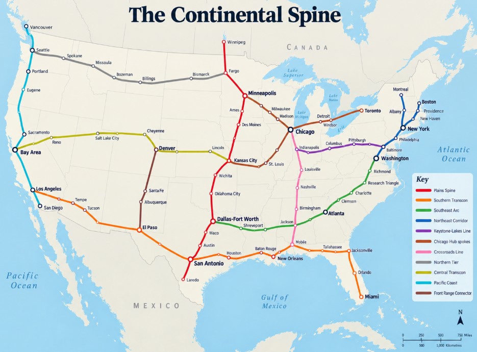
Three switchyards. Texas, Chicago and the Northeast Corridor anchor the network. Texas faces Mexico and the hemisphere. Chicago sits where the lines from both coasts already meet. The Northeast Corridor holds the densest cluster of cities and campuses in the country.
The trunk lines.
1. Plains Spine (I-35 / BNSF)
Laredo – San Antonio (UTSA) – San Marcos (Texas State) – Austin (UT) – Waco (Baylor) – Dallas-Fort Worth – Norman (OU) – Oklahoma City – Stillwater (Oklahoma State) – Wichita – Lawrence (KU) – Kansas City – Ames (Iowa State) – Des Moines – Minneapolis (Minnesota)
Spur north: Minneapolis – Fargo (NDSU) – Winnipeg
2. Southern Transcon (I-10 / UP Sunset Route)
West: San Antonio – El Paso (UTEP) – Tucson (Arizona) – Tempe (ASU) – Los Angeles
East: Houston (Rice, UH) – Baton Rouge (LSU) – New Orleans (Tulane) – Mobile – Tallahassee (FSU) – Jacksonville, tying into Brightline for Orlando and Miami
3. Southeast Arc (I-20 / I-85)
Dallas-Fort Worth – Shreveport – Jackson – Birmingham (UAB) – Atlanta (Georgia Tech, Emory) – Clemson – Charlotte – Research Triangle (Duke, UNC, NC State) – Richmond – Washington
4. Northeast Corridor (upgraded)
Washington – Baltimore (Johns Hopkins) – Philadelphia (Penn) – New York – New Haven (Yale) – Providence (Brown) – Boston (Harvard, MIT)
Spur north: New York – Albany – Montreal
5. Keystone-Lakes Line
Philadelphia – Harrisburg – State College (Penn State) – Altoona – Johnstown – Pittsburgh (Carnegie Mellon, Pitt) – Columbus (Ohio State) – Indianapolis – West Lafayette (Purdue) – Chicago
6. Chicago Hub spokes
Chicago – Champaign (Illinois) – St. Louis (WashU) – Kansas City
Chicago – Ann Arbor (Michigan) – Detroit – Windsor – Toronto
Chicago – Milwaukee – Madison (Wisconsin) – Minneapolis
7. Crossroads Line (I-65)
Chicago – West Lafayette (Purdue) – Indianapolis (IU Indianapolis, with Bloomington close by) – Louisville (UofL) – Bowling Green (Western Kentucky) – Nashville (Vanderbilt) – Huntsville – Birmingham (UAB) – Montgomery – Mobile (South Alabama)
Shares the Chicago-Indianapolis stretch with the Keystone-Lakes Line. Crosses the Southeast Arc at Birmingham and meets the Southern Transcon at Mobile, turning the eastern lines from parallel strings into a grid.
8. Northern Tier (I-94 / I-90 / BNSF)
Minneapolis – Fargo (NDSU) – Bismarck – Billings – Bozeman (Montana State) – Missoula (University of Montana) – Spokane (Gonzaga, with WSU and Idaho a short spur south) – Seattle (UW)
Closes the northern loop between the Plains Spine and the Pacific Coast, with Yellowstone and Glacier country along the way.
9. Central Transcon (I-80 / UP Overland Route)
Kansas City – Lincoln (Nebraska) – Denver and Boulder (Colorado) – Cheyenne – Salt Lake City (Utah) – Reno – Sacramento (UC Davis) – Bay Area (Berkeley, Stanford)
The Overland Route over Wyoming climbs gentler grades than I-70 through the Colorado Rockies.
10. Pacific Coast (California HSR and Cascadia)
San Diego (UCSD) – Los Angeles (UCLA, USC) – Bay Area – Sacramento – Eugene (Oregon) – Portland – Seattle (UW) – Vancouver (UBC)
11. Front Range Connector
El Paso – Albuquerque (UNM) – Santa Fe – Denver
The campuses are the stops. Each trunk threads through flagships and research universities. Students, faculty, visiting researchers, conference crowds and game-day fans give the line a steady pulse between the big cities. More to the point, the campuses stop being islands. A lab in Ames and a lab in Austin become a two-hour ride apart. The friction that keeps people from crossing paths, the airport security line, the six-hour drive, the rental car, drops out of the picture.
The gates. Four crossings to Mexico: Laredo, El Paso, Nogales and San Diego. Four to Canada: Vancouver, Winnipeg, Toronto and Montreal. South of Mexico, the long corridor runs through Central America to the Darién, as Lone Star Junction laid out.
INTERVENE
This is a federal project, and the playbook runs through Washington.
1. Pass a National High-Speed Rail Act. Create a federal authority with the national map, the money and the power to acquire right-of-way, using the 1956 highway act as the template. States become construction partners.
2. Reclaim the corridors for public use. Expand the existing federal power to acquire rail-carrier property for passenger service. Freight carriers keep operating rights on shared corridors, so the goods still move while the public regains the ground under them.
3. Reserve the medians. The interstates were built with federal money. A federal rule can reserve their center lines for rail.
4. Put conditions on the merger. The Union Pacific–Norfolk Southern review is a federal proceeding. Passenger right-of-way access belongs on the list of conditions for approval.
5. Open the border tables. Binational agreements with Mexico and Canada for the gates, customs stations and shared standards, with Central America on the agenda.
6. Build in sequence, then let the money run.
- Phase one: Finish the Texas triangle and the Laredo link to Mexico’s line.
- Phase two: Build the Plains Spine and upgrade the Northeast Corridor at the same time. The Plains Spine carries the Texas junction north; the Northeast Corridor serves the densest market already riding trains.
- Phase three: The Chicago spokes, starting with Kansas City to Chicago.
- Phase four: Once the corridor from San Antonio to Kansas City shows its economic growth and the Kansas City–Chicago line breaks ground, the financing lines up behind a proven model. The remaining trunks build at once, from the Crossroads Line to the Northern Tier.
The early phases do the convincing. A working spine from the border to Kansas City, full of students, researchers and business travelers, makes the case better than any study. After that, the rest of the country will want its line, the way towns lined up to get on the interstate once they saw what it did for the towns already on it.
Sources
- Blue Ribbon Team, The Lone Star Junction: https://blueribbonteam.com/blog/2026/10/20/the-lone-star-junction/
- Blue Ribbon Team, The Keystone Network: https://blueribbonteam.com/blog/2026/01/14/the-keystone-network/
- Railmarket, STB accepts Union Pacific–Norfolk Southern merger application: https://railmarket.com/news/business/57579-us-surface-transportation-board-accepts-union-pacific-norfolk-southern-merger-application
- Surface Transportation Board, UP–NS environmental review, Docket FD 36873: https://www.stb.gov/upns-eis-fd36873/
- Western Ag Network, UP and NS resubmit merger application amid opposition: https://westernagnetwork.com/up-and-ns-resubmit-merger-application-to-stb-amid-growing-opposition