Man Made: Chicago, From the South Shore
April 2025
The best way to look at Chicago is from the wrong end of it.
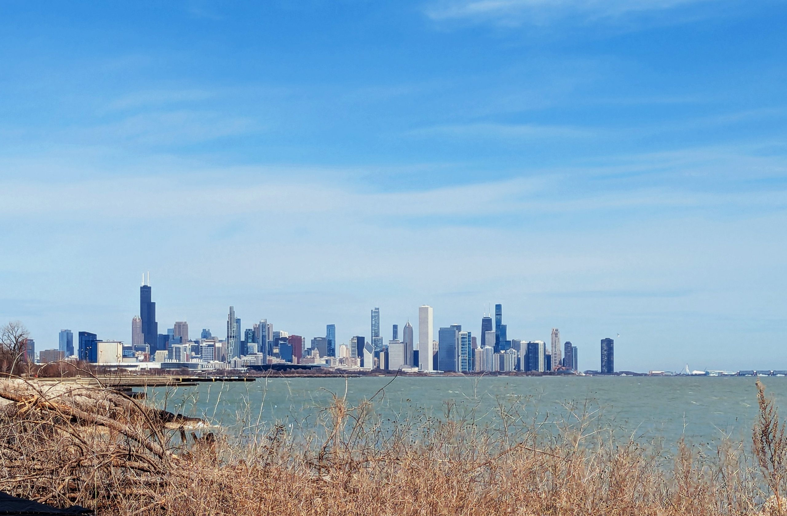
Everybody shoots the skyline from the Adler, from the lakefront path, from a boat. Head-on, centered, postcard. Stand down on the South Shore instead and you get the honest version — the whole city compressed into a strip about an inch tall, floating on green water the better part of ten miles away, with dead goldenrod and driftwood in the foreground because that’s what’s actually under your feet in April.
The lake does the work here. Nine miles of open water flattens the perspective until the buildings stop being individual towers and start being one object. A single serrated thing sitting on the horizon. You can see the whole shape of a decision that took a hundred and thirty years to make.
Left side, the twin antennas — Willis. Still the anchor, still the thing your eye lands on first whether you want it to or not. Center-right, the pale slab is the Aon Center, which was the Standard Oil Building, which was clad in Italian marble until the marble started falling off and they re-skinned the entire thing in granite. Right of that, the X-braced tower with its own pair of antennas is the Hancock. And out on the far right, standing off by itself past the end of the cluster, is Lake Point Tower — dark, curved, alone, built on landfill in 1968 and never given a neighbor.
That’s the part worth talking about.
Because there’s a stretch of empty sky just left of Lake Point Tower in this frame, right where the river meets the lake, and that gap doesn’t exist anymore.
For sixteen years that ground held a hole. Literally — a round concrete foundation shaft, a hundred and ten feet across, dug for the Chicago Spire in 2007 and abandoned when the financing evaporated in 2008. Calatrava’s twisting two-thousand-foot needle. It would have been the tallest building in the country. Instead it was a flooded pit behind a construction fence, visible from the lake, for the better part of two decades.
They filled it. Related Midwest started building on the site in 2024, and when I made this photo in April of 2025 the North Tower at 400 Lake Shore Drive hadn’t reached a height that reads from this distance. From the South Shore it was nothing. A crane, maybe, if you knew where to look and had better glass than I did.
It topped out this spring. Seventy-two stories, a little over eight hundred and fifty feet, glass curtain wall faceted to reference the Chicago bay window, designed by SOM and by David Childs, who did One World Trade and who died before he saw this one finished. Exterior went substantially complete a few weeks ago. Residents move in next spring, and a second tower is planned beside it.
So this photograph is already historical. Fifteen months old and it documents a skyline that no longer exists in this configuration. That gap on the right is filled. The city closed the wound where the Spire was supposed to go, and it took eighteen years.
That’s the thing about photographing a skyline. You think you’re making a picture of a place. You’re making a picture of a date.
I’ll go back and shoot it again from the same bank, same season, same dead weeds, and put the two side by side. That’s a better document than either one alone — not because the new tower is beautiful, though it might be, but because the difference between the two frames is the only honest way to show a city doing what cities do.
Chicago. From the South Shore. April 2025. Already out of date.