A Bright Meadow Group look at the Central Transcontinental line, Kansas City to the Bay Area, and the western connectors that grow from it
It seems odd for this line to come this late in the series. The Central Transcontinental follows the route of the first railroad to cross the continent, and that railroad made the United States what it became. This piece finishes the line-by-line descriptions of the network. It covers the Central Transcon itself, the two other western crossings, and the connectors that would carry high-speed rail to the West’s smaller cities.
OBSERVE
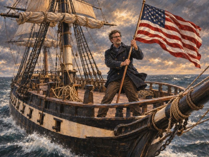
In 1862, in the middle of the Civil War, Congress passed the Pacific Railway Act. The Union Pacific built west from Council Bluffs and Omaha. The Central Pacific built east from Sacramento over the Sierra Nevada. The two met at Promontory Summit in Utah in May 1869. A trip from coast to coast that had taken months by wagon or by ship around South America dropped to about a week.
It’s hard to overstate what came next. The United States had always been huge, isolated behind two oceans, and diverse. After 1869 it could act as one country from coast to coast. It held ports on two oceans, and those ports could support each other because goods, troops and people could cross the continent between them. A nation spread across a continent became a nation that could use the continent. For the century that followed, no other power could match that reach.
The route is still there. Union Pacific runs the Overland Route from Nebraska across Wyoming and Utah to Nevada and California, close to the original line. Interstate 80 runs beside much of it. The Overland Route crosses Wyoming on gentler grades than I-70 takes through the Colorado Rockies, which is why The Continental Spine routes the line north through Cheyenne instead of west from Denver through the mountains.
The West has grown into the space the railroad opened. Denver, Salt Lake City, Boise, Reno, Las Vegas and Albuquerque have grown fast. Colorado’s Front Range runs as a nearly continuous string of cities from Pueblo to Fort Collins. The West’s smaller cities are filling in the map between the big ones, and they’re linked by long highways and short-hop flights.
DESIGN
The Central Transcon.
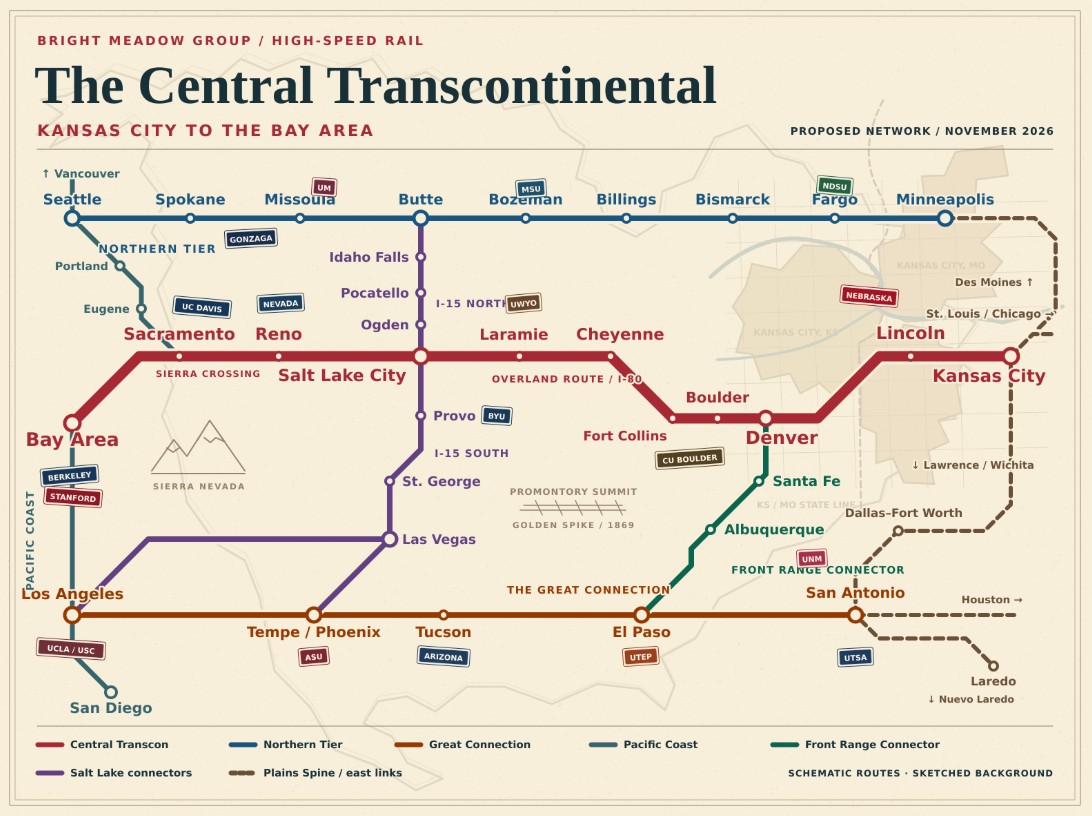
Kansas City – Lincoln (Nebraska) – Denver and Boulder (Colorado) – Cheyenne – Salt Lake City (Utah) – Reno – Sacramento (UC Davis) – Bay Area (Berkeley, Stanford)
The line leaves the Plains Spine at Kansas City, crosses Nebraska’s flat country, and reaches Denver at the foot of the Rockies. From Denver it runs north along the Front Range to Cheyenne, then west over the Overland Route across Wyoming to Salt Lake City. It crosses the Great Basin to Reno, climbs the Sierra to Sacramento, and finishes at the Bay Area. The Sierra crossing, where the Central Pacific’s crews cut tunnels through granite in the 1860s, is the hardest stretch of track in the network.
The three crossings. With the Central Transcon in place, the network crosses the West three times.
The Northern Tier runs from Minneapolis through Fargo, Bismarck, Billings, Bozeman, Missoula and Spokane to Seattle.
The Central Transcon runs from Kansas City through Denver and Salt Lake City to the Bay Area.
The Great Connection runs from San Antonio through El Paso, Tucson and Tempe to Los Angeles and San Diego.
Each one ends at a Pacific port: Seattle, Oakland, Los Angeles and Long Beach. Each one starts at the Plains Spine or the Texas triangle. The ports on the two coasts that the first railroad tied together get tied together three times over, with the Pacific Coast line running north and south between them.
The connectors. The crossings run east and west. The connectors run north and south between them, and they reach the West’s smaller cities.
The Front Range Connector. El Paso – Albuquerque (UNM) – Santa Fe – Denver, as The Continental Spine laid it out. It joins The Great Connection at El Paso to the Central Transcon at Denver, and puts New Mexico’s cities on the network.
The Salt Lake connectors. Salt Lake City sits on the Central Transcon at the junction of two interstates that run the length of the mountain West. A connector north on I-15 runs through Ogden, Pocatello and Idaho Falls to Butte, meeting the Northern Tier between Bozeman and Missoula. A connector south on I-15 runs through Provo (BYU) and St. George to Las Vegas, where it can continue to Los Angeles or turn southeast toward Phoenix and meet The Great Connection at Tempe. Salt Lake City becomes the junction of the mountain West, the city where all three crossings meet by a short ride.
The western cities. These lines carry high-speed rail to a set of cities that a national network would otherwise pass by: Lincoln, Boulder, Fort Collins, Cheyenne, Laramie, Ogden, Provo, Pocatello, Idaho Falls, Butte, St. George, Las Vegas, Reno, Albuquerque and Santa Fe. These are places with growing populations, universities, and long drives to the next city. On the network, a student at the University of Wyoming in Laramie can spend a weekend in Denver. A Pocatello family can reach Salt Lake City for a ball game and Boise or Bozeman for a weekend away. A Reno business can serve Sacramento and Salt Lake City in the same week.
The West gets a second expansion. The first railroad opened the West to settlement. High-speed rail opens it to the rest of the country as a place people can live and still reach. A software engineer in Bozeman stays connected to Seattle and Salt Lake City. A researcher in Albuquerque works with colleagues in Denver and El Paso. The West’s smaller cities stop being remote and become neighbors to its big ones.
INTERVENE
- Write the Central Transcon into the National High-Speed Rail Act along the Overland Route, from Kansas City to the Bay Area.
- Make Overland Route access a condition of the Union Pacific–Norfolk Southern merger. Union Pacific owns the original transcontinental route, and passenger right-of-way along it belongs among the terms.
- Reserve the I-80 median for rail where the highway runs straight and flat across Nebraska, Wyoming and Nevada.
- Fund the Sierra crossing as its own project, with the tunnels and grade work the mountains require, so the hardest stretch doesn’t hold up the rest of the line.
- Plan the connectors from the start. The Front Range Connector and the Salt Lake connectors north and south go into the national map with the trunks, so the junction stations at El Paso, Denver, Salt Lake City and Butte are built to receive them.
- Let the smaller cities buy in. State and local governments along the connectors can fund stations and spurs of their own, the way towns lined up to get on the interstate once they saw what it did for the towns already on it.
Sources
Blue Ribbon Team, The Continental Spine: https://blueribbonteam.com/blog/2026/10/21/the-continental-spine/
Blue Ribbon Team, The Lone Star Junction: https://blueribbonteam.com/blog/2026/10/20/the-lone-star-junction/
Surface Transportation Board, UP–NS environmental review, Docket FD 36873: https://www.stb.gov/upns-eis-fd36873/