A Bright Meadow Group analysis in the Continental Spine series
Stand on an overpass above I-5 at rush hour in Los Angeles and you’re looking at the Pacific Coast’s economy stuck in a hallway. Commuters, tourists, delivery vans and container trucks fresh off the docks share the same lanes, moving like toothpaste squeezed from the middle of the tube.
In The Continental Spine, Bright Meadow Group laid out a federal high-speed rail network built on interstate medians and existing rail corridors, anchored by three switchyards in Texas, Chicago and the Northeast Corridor. Line 8 on that map, the Pacific Coast trunk, ran from San Diego through Los Angeles, the Bay Area, Sacramento, Eugene, Portland and Seattle to Vancouver. This piece zooms in on that line, starting with its densest leg, Los Angeles to San Francisco, and stretches it at both ends, from Tijuana to Anchorage.
The corridor holds San Diego, Los Angeles, the Bay Area, Sacramento, Portland, Seattle and Vancouver. It also holds the deepest pool of venture money on the planet, the two ports that handle the bulk of America’s Asian imports, and a coastline people fly across oceans to see. A train should have run this coast decades ago. Here is why it hasn’t, and how to build it with a resource the public already owns: two lanes of Interstate 5.
OBSERVE
The ports. The Port of Los Angeles moved 10.2 million containers in 2025. Long Beach, next door, set its own all-time record at 9.9 million. Together they form the San Pedro Bay complex, the Western Hemisphere’s busiest container gateway, and Long Beach expects to handle 20 million containers a year by 2050. Those boxes leave the docks by truck and rail, and the trucks run straight into the commuter traffic.
The trains that exist. California voters approved a high-speed rail bond in 2008 for a San Francisco–Los Angeles line. Eighteen years later the project is building its first operating segment, between Merced and Bakersfield, with an opening estimated for 2033 at the earliest. Cost estimates have climbed past $100 billion. Roughly $5 billion in federal grants was pulled in 2025 and 2026, and state law currently limits the Authority’s spending to that Central Valley segment. Up north, Washington, Oregon and British Columbia have a $55 million study underway for a 250 mph Cascadia line linking Portland, Seattle and Vancouver in roughly an hour per leg, with a service plan due in 2028. Today’s Amtrak Cascades trains share track with freight and top out at 79 mph.
The gap in the map. North of Vancouver there is no passenger rail to Alaska, and no freight link either. The Alaska Railroad runs as an island. A private freight project, the Alaska-to-Alberta Railway, proposed a line of about 1,600 miles from Delta Junction to northern Alberta. It received a U.S. presidential border permit, then stalled.
Why it hasn’t happened. The coast is one corridor run by seven governments: Baja California, California, Oregon, Washington, British Columbia, Yukon and Alaska, across three countries. Each plans its own piece on its own clock, like a relay race where each runner trains in a different stadium and nobody owns the baton. California’s project spent years buying farmland, relocating utilities and negotiating city by city through the Valley. The land problem is real, and the I-5 approach solves it.
DESIGN
The road we already own. I-5 runs 1,381 miles from the Mexican border at San Ysidro to the Canadian border at Blaine. The public paid for it, the right-of-way is graded, and the alignment through the western Central Valley is close to a ruler line across flat ground. A high-speed train wants straight, flat and uninterrupted track, and that’s what Eisenhower’s engineers left us.
The trade. A freeway lane moves around 2,000 vehicles an hour, so two lanes carry roughly 4,000 to 5,000 people an hour at commuter occupancy. A double-track high-speed line running a train every five minutes moves several times that number in each direction. Give the train two lanes, and commuters who hop on take their cars off the remaining lanes. The target is to clear half the commuter traffic. The lanes that open up go to freight: dedicated truck lanes from the San Pedro Bay docks, Oakland, Portland, Tacoma and Seattle, so containers stop idling behind people driving to work.
Alignment rules. The Continental Spine set four rules for the national network: interstate medians first, then a dedicated track pair beside existing freight lines, then federal reclamation where an owner won’t share, and new alignment only for mountain crossings and city entries. The Pacific Run applies them this way:
- Take two lanes in the wide urban stretches: San Diego, Orange County, the Los Angeles basin, the Bay Area approaches, Seattle–Tacoma. I-5 reaches 21 to 22 lanes at its widest merges, and two of them go to the train.
- Use the median and shoulder right-of-way through the Central Valley, the Willamette Valley and western Washington, where the road runs four to six lanes across open country.
- Tunnel the passes. The Grapevine over the Tehachapis and the Siskiyous on the Oregon border climb too steep and curve too tight for 200 mph. Those get new alignment, the way the Swiss bore under the Alps instead of following the switchbacks.
- Enter cities at the existing hubs: Union Station in Los Angeles, the Salesforce Transit Center in San Francisco, King Street in Seattle, Pacific Central in Vancouver.
Express and local. The I-5 line serves as the express spine, Los Angeles to the Bay Area in under three hours with few stops. California’s high-speed route along Highway 99 through Bakersfield, Fresno and Merced becomes the local line serving the Valley cities. The two meet at both ends, the way a subway runs express and local tracks side by side.
Tying the transcons together. On the Continental Spine map, the Central Transcon runs the Overland Route from Kansas City through Denver, Salt Lake City and Reno into Sacramento and the Bay Area. The Southern Transcon runs the Sunset Route from San Antonio through El Paso, Tucson and Phoenix into Los Angeles. The Pacific Run connects those two western terminals, so a rider from Denver can reach San Diego, and a rider from Phoenix can reach Seattle, without leaving the network.
The leg in focus: Los Angeles to San Francisco.
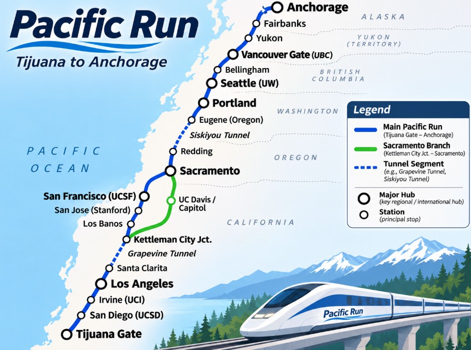
Los Angeles Union Station (UCLA, USC) – Santa Clarita – Grapevine tunnel – Kettleman City junction (cross-connect to the Valley line) – Los Banos – San Jose (Stanford) – San Francisco (UCSF), with a Sacramento branch to UC Davis, the Capitol and the Central Transcon.
The full Pacific Run.
Tijuana gate – San Diego (UCSD) – Irvine (UCI) – Los Angeles – Bay Area – Sacramento – Redding – Siskiyou tunnel – Eugene (Oregon) – Portland – Seattle (UW) – Bellingham – Vancouver gate (UBC) – then north along the A2A corridor through the Yukon to Fairbanks and Anchorage.
The north leg. North of Vancouver the population thins out and the freight case takes over. The line through the Yukon runs as a mixed corridor: freight trains carry Asian cargo to and from the Port of Alaska, with scheduled passenger service riding alongside. The scenery does the marketing. A sleeper car from Seattle to Anchorage through the Coast Mountains is a trip people would book a year out.
INTERVENE
The Continental Spine put the playbook in Washington’s hands. The Pacific Run follows the same playbook.
1. Name the Pacific Run in the National High-Speed Rail Act. The act proposed in The Continental Spine creates a federal authority with the map, the money and the power to acquire right-of-way. I-5 becomes a named corridor.
2. Reserve the lanes along with the medians. The base article called for a federal rule reserving interstate center lines for rail, since the interstates were built with federal money. On I-5 that rule extends to two travel lanes in the urban stretches, through lane-transfer agreements with Caltrans, ODOT and WSDOT, segment by segment, starting with Los Angeles to the Bay Area.
3. Let California spend outside the Valley. The Legislature amends the statute that confines the High-Speed Rail Authority to Merced–Bakersfield, so the state can partner on the I-5 express and tie its Valley line in at Kettleman City.
4. Toll the freed lanes for freight. Lanes cleared by commuters become priced truck lanes from the ports. The tolls pay toward the train, and the trucking industry gets a reliable trip in exchange.
5. Open the gates. The Continental Spine named San Diego/Tijuana and Vancouver as two of its eight border gates. Binational agreements set up precleared customs at both stations, the way travelers already clear U.S. customs at Vancouver’s airport. North of Vancouver, revive the A2A permit as a joint freight and passenger corridor with Canada, Yukon and the First Nations along the route.
6. Build in sequence. In the national phasing, the western lines fall in phase four, once the Texas triangle, the Plains Spine and the Chicago spokes show results. The Pacific Run can start early inside that phase, because its land is already public.
- First: Los Angeles to San Francisco on I-5, the densest leg, with the land already in hand.
- Second: San Diego and the Tijuana gate south, Sacramento north to meet the Central Transcon.
- Third: Join Cascadia’s Portland–Seattle–Vancouver line through Oregon and the Siskiyou tunnel.
- Fourth: The north leg to Anchorage, once the freight numbers from the southern ports show what the corridor carries.
BMG Assessment
The Pacific Coast has the riders, the money, the cargo and the view. What it lacks is a single owner for the corridor and a cheap way to get the land. The Continental Spine answered the ownership question with federal action. Two lanes of I-5 answer the land question. California has already proven it can build the hard civil works in the Valley. Running the express line down the interstate turns that work into half of a two-track system. Each commuter who boards in Irvine or San Jose hands a lane back to a container truck headed for Long Beach.
Sources:
- Bright Meadow Group, “The Continental Spine,” Blue Ribbon Team, Oct. 21, 2026: https://blueribbonteam.com/blog/2026/10/21/the-continental-spine/
- FreightWaves, “Port of Los Angeles tops 10M containers for third time”: https://www.freightwaves.com/news/port-of-los-angeles-tops-10m-containers-for-third-time
- Container News, “Port of Long Beach moves nearly 9.9 million TEUs in 2025”: https://container-news.com/port-of-long-beach-moves-nearly-9-9-million-teus-in-2025
- The Bond Buyer, “L.A., Long Beach ports notched strong year despite trade volatility”: https://www.bondbuyer.com/news/l-a-long-beach-ports-notched-strong-year-despite-trade-volatility
- Railway News, “California High-Speed Rail 2026: SF-LA Timeline, Cost & Route Map”: https://railwaynews.net/california-high-speed-rail-project-san-francisco-los-angeles-hsr-network.html
- Transbay Joint Powers Authority, CHSRA briefing, June 2026: https://www.tjpa.org/media/40422
- High Speed Rail Alliance, “California is Building High Speed Rail”: https://www.hsrail.org/?p=25909
- WSDOT, Cascadia High-Speed Rail: https://wsdot.wa.gov/construction-planning/search-studies/cascadia-high-speed-rail
- KGW, “Portland-Seattle-Vancouver high-speed rail idea lands $49.7 million federal grant”: https://kgw.com/article/news/local/washington-gets-federal-grant-study-chigh-speed-rail/283-7835d1a7-af8b-4a3b-8296-1d1c8b699907
- CBC, “Trump issues presidential permit authorizing $22B railway between Alaska and Alberta”: https://amp.cbc.ca/news/canada/calgary/a2a-railway-1.5744023
- Alaska Business, “Is A2A Staying on Track?”: https://www.akbizmag.com/industry/transportation/is-a2a-staying-on-track/
- Wikipedia, Interstate 805 (I-5/I-805 merge width): https://en.wikipedia.org/wiki/Interstate_805
- AARoads, Interstate 5 south (El Toro Y width): https://www.aaroads.com/california/i-005st_ca.html